santa susana mtns - mission peak
(via latimes.com)
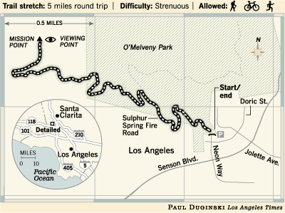
saturday was a short ride, about 10 miles, up and back down mission peak (also called "secret of the three trees") in granada hills. it's about 40 minutes from the south bay, just make sure your car can take the hilly trek up and over the mountains into the valley.
the mission peak climb lasts about an hour, depending on how much you rely on downshifting to an easier (and slower) gear, a distance of about 2.5 miles. in some places it's so steep that hikers will be lapping you, but the views are amazing, so feel free to take your time.
near the top, an iron fence cuts off what used to be a nice easy switchback trail to the summit. after 9/11, the local gas co cordoned off the area to protect the supposed large natural gas deposit from terrorists. but you can easily circumnavigate the fence - well, it's easier if you're on foot. ambitious bikers will have to power up a nearly 60 degree slope that's powdery and loose.
we took the singletrack trail (you can also just go back down the fire road in reverse) down from the almost-summit, accessed via a path through a wire fence that starts to the left of the fire road if you're looking downhill. the singletrack is fun and fast, though pretty technical. it had a few long steep sections that tested the limits of my handling and ability to hold my focus. it's narrow and a little bit rutted too, so there's not a lot of room for error. if you don't know the trail, i def recommend taking it slow. and remember to take a break or two to check out the skyline! gorgeous.
the singletrack spits you out in omelveny park, which is right next to the suburb you parked in. once the easy gravel trail takes you back to paved surface streets, use the map you brought to find the way back to your car.
p.s. it's foggy in the spring
p.p.s. watch out for horses
p.p.p.s. the los angeles times has a nice piece on how to get to the hike/bike trail
*******************UPDATE /01/07 8:43am PST*******************
my friend peter continued on after i decided mission peak had given me enough exercise for the day and here's his tale of how it (another 15 miles of mtn biking) went...
After you left, we picked up the other rider, who was trying to meet us, but kept getting the directions wrong. We then headed off for some single track.and the trails they rode...
It started out as horse trails (there were those metal railings beside the trail to prevent horses from falling down). The terrain was rolling (not steep) and we worked our way downhill. There were 3 or 4 water crossings! Some of the water/mud that we went through was quite smelly!
There were also a couple of those short, steep drops and climbs that I like to topple over on!
The single track was not too technical, but was twisty enough to be fun. It was also fairly fast (the fast guys put on their body armor).
By 11:30 or 12 I had hit the wall and struggled to keep up (sorry, I didn’t represent us well).
Of the 100 oz of water that I carried, I think I only had about 20 or 30 oz left by the time I got home! I’m glad it wasn’t any warmer than it was.
We got back to Hans’ house about 1-1:30ish.
We took the trail just west of Limekiln Canyon Rd. and headed west, along the base of the Santa Susana Mountains.***********************END OF UPDATE***************************
After a while, it angled slightly north and into some shaded areas. We kept on the westward direction and finally came out at Brown’s Canyon Road.
Took this south and it turned into DeSoto Ave. Took DeSoto to just south of the freeway and turned left onto San Fernando Mission Blvd (it is a dirt access road at this point) and took it east to Limekiln Canyon.
From Limekiln Canyon, we went north a bit and pushed our bikes up a very steep hill to Rinaldi St (the more macho riders tried to ride up the steep hill [several times] and failed, even Louisa!). From Rinaldi, it was just a road ride back to Hans’ house.
posted by cattv at 6:41 AM
![]()
![]() permalink
permalink


0 Comments:
Post a Comment
<< Home